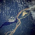
ملف:Manaus-Amazon-NASA.jpg

حجم هذه المعاينة: 600 × 600 بكسل. الأبعاد الأخرى: 240 × 240 بكسل | 480 × 480 بكسل | 768 × 768 بكسل | 1٬024 × 1٬024 بكسل | 2٬048 × 2٬048 بكسل | 5٬312 × 5٬312 بكسل.
الملف الأصلي (5٬312 × 5٬312 بكسل حجم الملف: 8٫7 ميجابايت، نوع MIME: image/jpeg)
تاريخ الملف
اضغط على زمن/تاريخ لرؤية الملف كما بدا في هذا الزمن.
| زمن/تاريخ | صورة مصغرة | الأبعاد | مستخدم | تعليق | |
|---|---|---|---|---|---|
| حالي | 05:17، 20 نوفمبر 2011 |  | 5٬312 × 5٬312 (8٫7 ميجابايت) | Delirium | much higher-resolution version from the same source |
| 04:38، 9 نوفمبر 2011 |  | 640 × 640 (262 كيلوبايت) | Creysmon07 | Corrected the contrast to a more realistic. | |
| 14:41، 29 يناير 2006 |  | 640 × 640 (157 كيلوبايت) | Maksim | La bildo estas kopiita de wikipedia:en. La originala priskribo estas: A satellite image of the city of Manaus with surrounding rivers. '''Original caption:''' :''STS61C-33-84 Manaus, Amazonas, Brazil January 1986'' :''Two rivers and an urban area d |
استخدام الملف
الصفحتان التاليتان تستخدمان هذا الملف:
الاستخدام العالمي للملف
الويكيات الأخرى التالية تستخدم هذا الملف:
- الاستخدام في azb.wiki.x.io
- الاستخدام في be.wiki.x.io
- الاستخدام في bo.wiki.x.io
- الاستخدام في ce.wiki.x.io
- الاستخدام في cs.wiki.x.io
- الاستخدام في de.wiki.x.io
- الاستخدام في de.wikinews.org
- الاستخدام في en.wiki.x.io
- الاستخدام في en.wikinews.org
- الاستخدام في eo.wiki.x.io
- الاستخدام في et.wiki.x.io
- الاستخدام في fa.wiki.x.io
- الاستخدام في fi.wiki.x.io
- الاستخدام في fr.wiki.x.io
- الاستخدام في hr.wiki.x.io
- الاستخدام في id.wiki.x.io
- الاستخدام في ja.wiki.x.io
- الاستخدام في li.wiki.x.io
- الاستخدام في ml.wiki.x.io
- الاستخدام في nl.wiki.x.io
- الاستخدام في no.wiki.x.io
- الاستخدام في pt.wiki.x.io
- الاستخدام في ro.wiki.x.io
- الاستخدام في ru.wiki.x.io
- الاستخدام في sl.wiki.x.io
- الاستخدام في sv.wiki.x.io
- الاستخدام في uk.wiki.x.io
- الاستخدام في ur.wiki.x.io
- الاستخدام في www.wikidata.org
- الاستخدام في zh-yue.wiki.x.io
- الاستخدام في zh.wiki.x.io


