ملف:Mediterranean Sea political map-es.svg

حجم معاينة PNG لذلك الملف ذي الامتداد SVG: 800 × 585 بكسل. الأبعاد الأخرى: 320 × 234 بكسل | 640 × 468 بكسل | 1٬024 × 749 بكسل | 1٬280 × 936 بكسل | 2٬560 × 1٬872 بكسل | 2٬046 × 1٬496 بكسل.
الملف الأصلي (ملف SVG، أبعاده 2٬046 × 1٬496 بكسل، حجم الملف: 1٫1 ميجابايت)
| هذا ملف من ويكيميديا كومنز. معلومات من صفحة وصفه مبينة في الأسفل. كومنز مستودع ملفات ميديا ذو رخصة حرة. |
| الوصف |
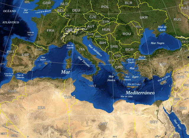
English: Map in Spanish of the Mediterranean Sea, with the borders and the name of the States following the ISO 3166-1 Alpha-3 code. Español: Mapa en español del Mar Mediterraneo con las fronteras y los nombres de los estados siguiendo el código ISO 3166-1 Alpha-3. |
| التاريخ | (UTC) |
| المصدر | |
| المؤلف |
|
| هذا رسمٌ مُعَدَّلٌ رقميَّاً من النسخة الأصليَّة. التعديلات هي: Versión en español. يُمكن الاطلاع على النسخة الأصليَّة هنا: Mediterranean Sea political map-en.svg:
|
| هذه الصُّورة في النِّطاق العامِّ لأنها لقطة شاشةٍ مِن تطبيق وُرد ويند الخاصِّ بوكالة الفضاء الأمريكيَّة مأخوذةٌ مِن نمطٍ يَستعمل طَبقةً مَوجُودةً في النِّطاق العامِّ أساساً.
|
 |
| This work was previously under Public Domain, or a Free License. It has been digitally enhanced and/or modified. This derivative work has been (or is hereby) released into the public domain by its author, [[:{{{1}}}:User:{{{3}}}|{{{3}}}]] at the [[:{{{1}}}:|{{{2}}}]] project. This applies worldwide. In some countries this is not legally possible; if so:
|
سجلُّ الرَّفع الأصيل
This image is a derivative work of the following images:
- File:Mediterranean_Sea_political_map-en.svg licensed with PD-WorldWind, PD-retouched-user-w
- 2008-05-19T16:18:12Z Sting 2046x1496 (1148854 Bytes) "Tropic of Cancer" label correction
- 2007-06-21T01:01:36Z Sting 2046x1496 (1148419 Bytes) {{Information |Description=Map in English of the [[:en:Mediterranean Sea|Mediterranean Sea]], with the borders and the name of the States following the ISO 3166-1 Alpha-3 code. |Source=Own work ;Background map : screenshot fr
Uploaded with derivativeFX
تاريخ الملف
اضغط على زمن/تاريخ لرؤية الملف كما بدا في هذا الزمن.
| زمن/تاريخ | صورة مصغرة | الأبعاد | مستخدم | تعليق | |
|---|---|---|---|---|---|
| حالي | 18:32، 13 يونيو 2010 | | 2٬046 × 1٬496 (1٫1 ميجابايت) | Edoarado | Corregido error en "Océano Atlántico", el texto aparecía del revés. |
| 18:16، 13 يونيو 2010 |  | 2٬046 × 1٬496 (1٫1 ميجابايت) | Edoarado | {{Information |Description={{en|Map in Spanish of the Mediterranean Sea, with the borders and the name of the States following the ISO 3166-1 Alpha-3 code.}} {{es|Mapa en español del Mar Mediterraneo con |
استخدام الملف
الصفحة التالية تستخدم هذا الملف:
الاستخدام العالمي للملف
الويكيات الأخرى التالية تستخدم هذا الملف:
- الاستخدام في arz.wiki.x.io
- الاستخدام في ast.wiki.x.io
- الاستخدام في ca.wiki.x.io
- الاستخدام في el.wiki.x.io
- الاستخدام في en.wiki.x.io
- الاستخدام في es.wiki.x.io
- الاستخدام في eu.wiki.x.io
- الاستخدام في fi.wiktionary.org
- الاستخدام في fr.wikinews.org
- الاستخدام في ga.wiki.x.io
- الاستخدام في gl.wiki.x.io
- الاستخدام في ha.wiki.x.io
- الاستخدام في ia.wiki.x.io
- الاستخدام في kab.wiki.x.io
- الاستخدام في la.wiki.x.io
- الاستخدام في mzn.wiki.x.io
- الاستخدام في pnb.wiki.x.io
- الاستخدام في pt.wiki.x.io
- الاستخدام في vec.wiki.x.io
- الاستخدام في www.wikidata.org