ملف:Sahel Map-Africa rough.png

حجم هذه المعاينة: 800 × 370 بكسل. الأبعاد الأخرى: 320 × 148 بكسل | 640 × 296 بكسل | 1٬024 × 474 بكسل | 2٬000 × 925 بكسل.
الملف الأصلي (2٬000 × 925 بكسل حجم الملف: 291 كيلوبايت، نوع MIME: image/png)
| هذا ملف من ويكيميديا كومنز. معلومات من صفحة وصفه مبينة في الأسفل.
كومنز مستودع ملفات ميديا ذو رخصة حرة. |
| الوصف |
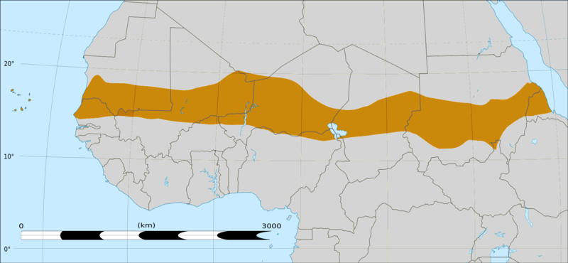
English: Map of Africa, with the Sahel highlighted in orange.
This is roughly the African land area between the lines of 200mm (north) and 600mm (south) mean 20th century annual rainfall. This is limited to land areas directly to the south of the Sahara desert and including the islands of Cape Verde, but not including other areas in Africa with the same rainfall statistics. This is one, but not the only, definition of the Sahel region. |
|||
| التاريخ | ٢٠ فبراير ٢٠٠٩ 03:54 (UTC) | |||
| المصدر |
Felix Koenig: "created/photographed by myself (based on the existing blank map of Africa)"
|
|||
| المؤلف | ||||
| إصدارات أخرى |
|


| هذا رسمٌ مُعَدَّلٌ رقميَّاً من النسخة الأصليَّة. التعديلات هي: Reproduced Sahel boundary from Map sahel.jpg on png map, cropped. يُمكن الاطلاع على النسخة الأصليَّة هنا: BlankMap-Africa2.png:
|
ترخيص
أنا، صاحب حقوق التأليف والنشر لهذا العمل، أنشر هذا العمل تحت الرخص التالية:

|
يسمح نسخ وتوزيع و/أو تعديل هذه الوثيقة تحت شروط رخصة جنو للوثائق الحرة، الإصدار 1.2 أو أي إصدار لاحق تنشره مؤسسة البرمجيات الحرة؛ دون أقسام ثابتة ودون نصوص أغلفة أمامية ودون نصوص أغلفة خلفية. نسخة من الرخصة تم تضمينها في القسم المسمى GNU Free Documentation License. |
هذا الملف مرخص بموجب Creative Commons Attribution-Share Alike 4.0 International , 3.0 غير مستورد, 2.5 عام، 2.0 عام و 1.0 عام الترخيص.
- يحقُّ لك:
- مشاركة العمل – نسخ العمل وتوزيعه وبثُّه
- إعادة إنتاج العمل – تعديل العمل
- حسب الشروط التالية:
- نسب العمل إلى مُؤَلِّفه – يلزم نسب العمل إلى مُؤَلِّفه بشكل مناسب وتوفير رابط للرخصة وتحديد ما إذا أجريت تغييرات. بالإمكان القيام بذلك بأية طريقة معقولة، ولكن ليس بأية طريقة تشير إلى أن المرخِّص يوافقك على الاستعمال.
- الإلزام بترخيص المُشتقات بالمثل – إذا أعدت إنتاج المواد أو غيرت فيها، فيلزم أن تنشر مساهماتك المُشتقَّة عن الأصل تحت ترخيص الأصل نفسه أو تحت ترخيص مُتوافِقٍ معه.
لك أن تختار الرخصة التي تناسبك.
|
|
يسمح نسخ وتوزيع و/أو تعديل هذه الوثيقة تحت شروط رخصة جنو للوثائق الحرة، الإصدار 1.2 أو أي إصدار لاحق تنشره مؤسسة البرمجيات الحرة؛ دون أقسام ثابتة ودون نصوص أغلفة أمامية ودون نصوص أغلفة خلفية. نسخة من الرخصة تم تضمينها في القسم المسمى GNU Free Documentation License. |
سجلُّ الرَّفع الأصيل
This image is a derivative work of the following images:
- File:Map_sahel.jpg licensed with GFDL
- 2005-05-30T17:36:46Z King 800x800 (89588 Bytes) one moment please
- File:BlankMap-Africa2.png licensed with Cc-by-sa-3.0,2.5,2.0,1.0, GFDL
- 2008-03-08T18:02:20Z Sadalmelik 1754x1546 (51013 Bytes) {{Information |Description=Blank map of Africa |Source=self-made |Date=2008-03-08 |Author= [[User:Sadalmelik|Sadalmelik]] |Permission= |other_versions= }} [[Category:Blank maps of Africa]]
Uploaded with derivativeFX
تاريخ الملف
اضغط على زمن/تاريخ لرؤية الملف كما بدا في هذا الزمن.
| زمن/تاريخ | صورة مصغرة | الأبعاد | مستخدم | تعليق | |
|---|---|---|---|---|---|
| حالي | 16:15، 17 مارس 2018 | | 2٬000 × 925 (291 كيلوبايت) | Maphobbyist | South Sudan border |
| 04:02، 20 فبراير 2009 |  | 1٬384 × 658 (29 كيلوبايت) | T L Miles | {{Information |Description=*Description: A map of Africa: the Sahel highlighted in orange. Note, this is ROUGHLY the African land area between the lines of 200mm (north) and 600mm (south) mean 20th century annual rainfall. This is limited to land areas d |
استخدام الملف
ال4 صفحات التالية تستخدم هذا الملف:
الاستخدام العالمي للملف
الويكيات الأخرى التالية تستخدم هذا الملف:
- الاستخدام في af.wiki.x.io
- الاستخدام في als.wiki.x.io
- الاستخدام في az.wiki.x.io
- الاستخدام في bcl.wiki.x.io
- الاستخدام في be.wiki.x.io
- الاستخدام في bg.wiki.x.io
- الاستخدام في bn.wiki.x.io
- الاستخدام في br.wiki.x.io
- الاستخدام في ca.wiki.x.io
- الاستخدام في ce.wiki.x.io
- الاستخدام في cy.wiki.x.io
- الاستخدام في da.wiki.x.io
- الاستخدام في en.wiki.x.io
- الاستخدام في eo.wiki.x.io
- الاستخدام في eu.wiki.x.io
- الاستخدام في fa.wiki.x.io
- الاستخدام في fi.wiktionary.org
- الاستخدام في fr.wiki.x.io
- الاستخدام في fr.wikinews.org
- الاستخدام في ha.wiki.x.io
- الاستخدام في ig.wiki.x.io
- الاستخدام في incubator.wikimedia.org
- الاستخدام في it.wiki.x.io
- الاستخدام في ja.wiki.x.io
- الاستخدام في ka.wiki.x.io
- الاستخدام في ko.wiki.x.io
اعرض المزيد من الاستخدام العام لهذا الملف.